Dublin's Temperature Surge
Urban Expansion or Global Warming?

Yesterday, RTE's George Lee reported on some of recent Manooth University research that suggests we are more likely to see extreme heat events in Ireland.
The leading quote was this:
Two years ago, on 18 July, the Phoenix Park weather station registered the warmest temperature ever recorded in the Dublin region. It was 33C, just below the nationwide all-time record of 33.3C.
While this quote is accurate, it presents only a partial picture. The article also goes on to say:
The answer they found was that temperatures that high have gone from a one-in-180-year-event to being a one-in-nine-year event in Ireland, making them 20 times more likely to occur. They also found the spatial impact of extreme heat has more than doubled here, meaning far more people will be impacted each time. Ireland could see 34C heat in three-to-five years
The article implies that this is a result of global climate change and does not consider local factors.
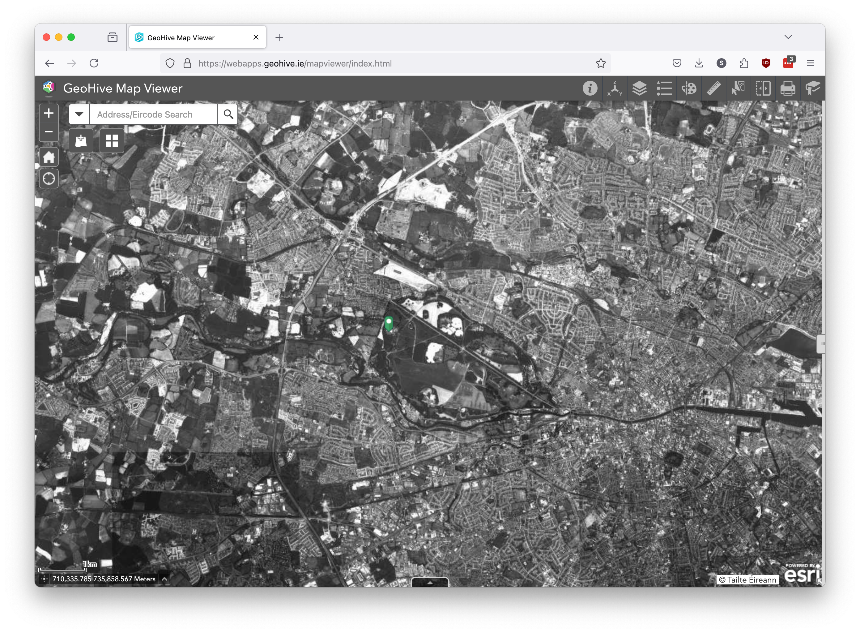
Let's just look at the highest temperature ever in Dublin at 33ºC on July 18, 2022 at the Phoenix Park weather station. The weather station, operational since 2003, is located at 53.364° N 6.350° W. If you look at this location in Google Maps you will see that it is slightly off, the actual location of the weather station is inside this fenced off square here.
You can also look at some of the historical photos of that location, currently at https://webapps.geohive.ie/mapviewer/index.html (Note: the people maintaining that service are updating the system and the links will change at some time).
Here’s the location using the 2013-2018 base map layer:

Using the geohive tooling you can measure that the weather station is 13m from the building on its left and 10m from the asphalt car park.
If you zoom out you can see just how much Dublin has changed. Here’s the 1995 base layer photos:
And here, using a ESA satellite image from https://www.esa.int/ESA_Multimedia/Images/2022/12/Dublin_Ireland is the same area some time in 2022, with the weather station location circled in red:
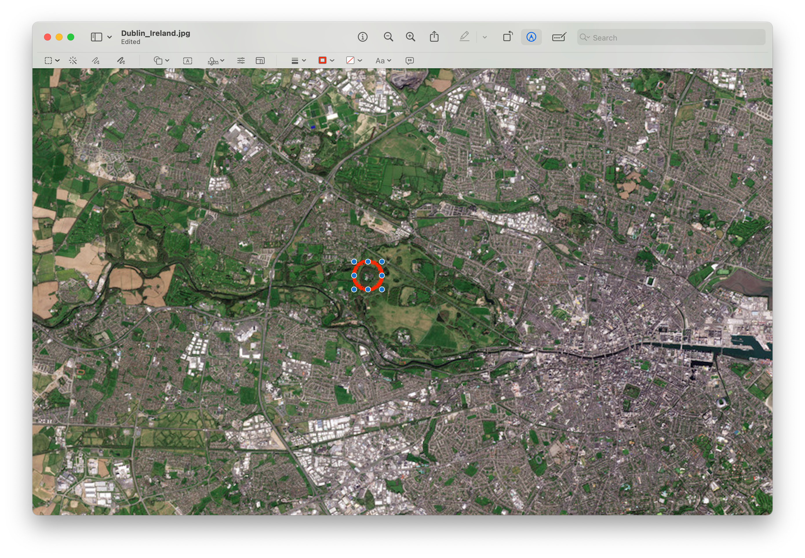
Comparing these two images we see just how much Dublin’s urban sprawl has grown, even just since 1995, for example:
Park West was not present in 1995
Lucan was separate from Dublin in 1995 but now there is near continuous housing from Chapelizod out through Liffey Valley to Lucan
Finglas has expanded to the West
Rosemount Business Park was not present in 1995
If we had aerial photography from 1900, I suspect it would show a major increase in our urban sprawl... while there are probably some hecklers who will point out that "the Wright Brother's didn't invent the airplane until 1903", hot air balloons were available since 1783, so you'll need to go looking for a different excuse as to why such photography is not available! 🤣
We have taken a lot of our green spaces and replaced them with suburban housing and nearer into the city center we have replaced lower density housing with higher density developments.
The Phoenix Park weather station is at risk of being affected by something known as the Urban Heat Island effect, a fancy name for something that your feet know… concrete and asphalt warm up faster in direct sunlight than green grass or forests… and they also retain heat for longer.
Dublin’s population has also grown in sync with the growth of urban regions, in 1995 it was approx. 0.945 million and now the population is approx. 1.285 million a growth of approx. 340,000 or 35%.
So Ireland has grown our urban areas, creating local climate change, and we have moved more people into these urban areas, exposing more people to the extremes of the Urban Heat Island effect… remember that quote from the RTE article?
They also found the spatial impact of extreme heat has more than doubled here, meaning far more people will be impacted each time.
I do not disagree with that sentence, and I think I have presented a reasonably solid argument to support it, but notice that I do not need to introduce any global climate changes to explain the observations. Even the next sentence, with it’s original emphasis in the article:
Ireland could see 34C heat in three-to-five years
I tend to agree, if we have weather stations in urban areas and we keep growing the urban areas, it is likely only a matter of time before we get a couple of really nice clear sunny days in a row with calm winds enough to let the concrete warm up enough to heat the air that blows over one urban weather station up to 34ºC.
The thing is that only about 5% of Ireland is actually urban… what exactly does a 34ºC urban temperature mean for the rest of Ireland?
Let’s take a look at Valentia Observatory, a purely rural weather station with a long history of records. We can look at the distribution of daily maximum temperatures for Valentia over the entire history from 1873 to present.
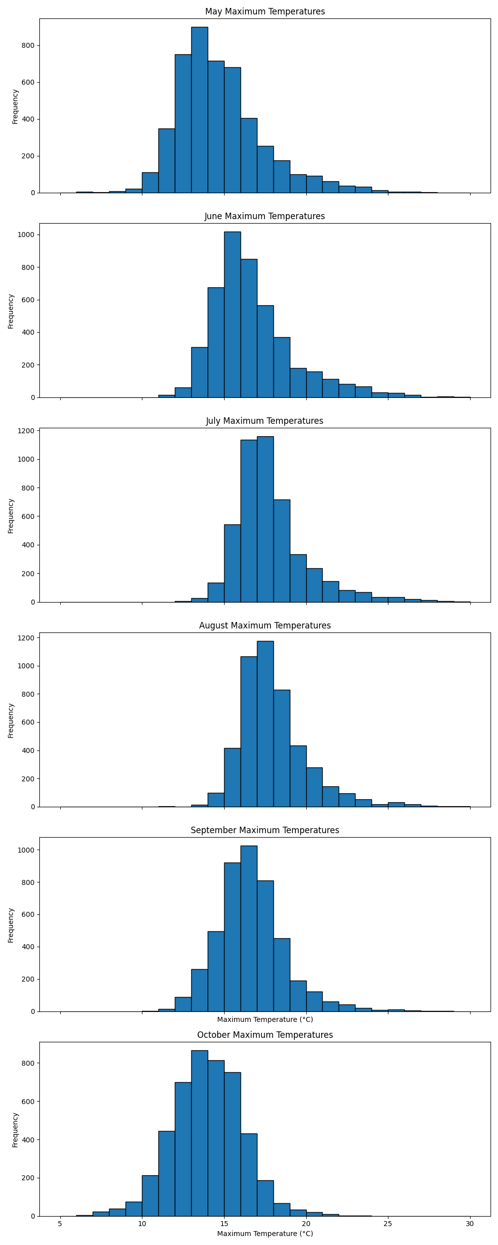
Valentia’s hottest days are most likely to occur in July or August.
So let’s now look at how the distribution of July-August daily maximum temperatures have varied by decade:
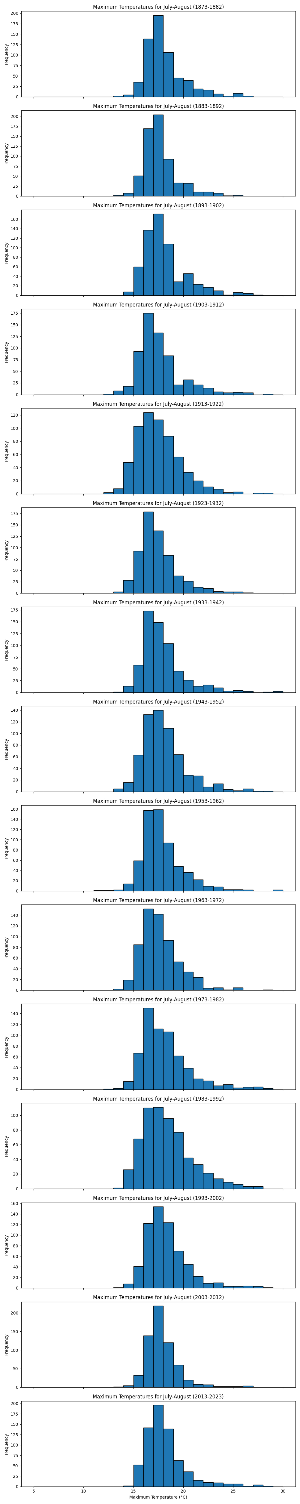
Those histogram plots can be a bit hard to see, so here's a graph of the average and variability of July-August daily maximum temperatures at Valentia Observatory
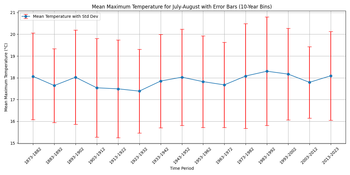
To me, the above graph says that rural Ireland is not seeing much if any warming and that the real climate problems we have to deal with are the local change caused by the growth of urban areas and the impact that has on the population which has predominantly relocated into urban areas too.
But that's just me, what do you think?
It proves what the censored climatologist say. Temperatures are always taken from heavily populated areas and airports where the tarmac on its own will increase the heat. They never take readings from uninhabited areas where the readings would more accurate. Gotta keep the green lies going to ensure the green bills keep flowing! Thank you very much for your analysis!
Excellent and important analysis!